Introduction
My travel since March 2020 with the onset of the COVID19 pandemic was extremely limited in sharp contrast to what had been the case for the last preceding two decades. My daughter, son-in-law and granddaughter live reasonably close (Nanaimo on Vancouver Island) so I have been able to visit them quite often since the start of the pandemic. However, it was the same for visits with my son, daughter-in-law and grandson because they live in Yellowknife. Due to pandemic complications in 2020, I was thwarted in my efforts to visit them on four occasions. By late spring of 2021, it became increasingly clear that a trip "North of 60" most likely would be possible in the summer/early fall. There were a few reasons behind the decision to make the journey North by road trip:
- In the late spring I significantly downsized my housing from a large townhouse to a condo. One aspect of my move was needing to pass along things belonging to my son and daughter. In my son's case, it meant getting his things from Victoria to Yellowknife. While one option would have been to ship, but the option that most appealed to me was taking a road trip to deliver the bins and boxes in person and also have a lengthy visit with them after so long.
- After receving my second COVID19 vaccination on June 21 (2021), I felt much safer for any kind of travel and by traveling alone in my own vehicle the chance of exposure to COVID was reduced compared to flying. In addition, my son and daughter-in-law had been fully vaccinated!
- Road trips are experiences I enjoy a great deal, especially over long distances. I have had several long distance road trips over the years and these have been a wonderful way to see the beauty and diversity of Canada. I have always found it interesting to drive through places (cities, towns and villages) mentioned in geography classes and history books during grade school and junior high.
- So far, I have driven at least 11 notable road trips in Canada of 2,000 km or more; in fact, two have exceeded 5,000 km. There have been many more road trips in the 500-1,000km range.
The Route/Timing
There are different route options for driving and, after some research, I chose a straightforward route via good highways that avoided larger cities with one exception. I took four days for the trip from Victoria to Yellowknife and the same number of days to return. No driving days were difficult and there were no traffic volume issues even though there was construction in a few places. A bonus was having good weather for virtually the entire trip and during my time in Yellowknife.
Map of driving route Victoria to Yellowknife
August 6: Left Victoria on the 7:00 am sailing via BC Ferries to the Mainland (see photo of the beautiful morning). After departing the ferry, I took a short diversion to stop at IKEA in Richmond to pick up something for the folks in Yellowknife. After a quick stop at IKEA, I took Highway #10 south of Vancouver to join the Trans Canada Highway (#1) in Langley and further along the highway at Hope I went north on the Coquihalla Highway (#5) and eventually stopping in Clearwater for the night. The hotel in Clearwater was basic and surprisingly busy as was the restaurant next door.
Clearwater has a population of about 2,500 and describes itself as the "Gateway to Wells Gray Provincial Park" as park's main entrance is there. The predominant local industries are forestry, tourism related to the outdoors/wilderness and sports services. Also, there is some agriculture in the surrounding area.
Ferry crossing
While I planned the entire route ahead of time and lodging had been booked before leaving home, I thought it might be necessary to divert from the planned route due to the wildfires quite close to Highway #5. Fortunately that did not happen, but there was much evidence of fire damage in a few places south of Merrit. The sky was hazy much of the day and soon after driving beyond Hope the air had a strong smell of smoke. Along the highway in a few places there was active smoke billowing up but no open flames. A few days later, I heard via CBC news that this highway was closed for a day or two due to wildfires. North of Kamloops and for the remainder of the entire route, however, the drought being experienced across southern BC had not occurred.
All the day one route was familiar to me as I had driven it a few times and once again I enjoyed the beautiful scenery. While I stopped a couple of places for short breaks to stretch, refuel and/or get a coffee, the focus was on driving.
August 7: After picking up a coffee to start the day, I was back on the road around 8:00 am with the first break planned for Valemount. I exited the highway and drove through the town centre hoping to find a local coffee shop for a light breakfast. That was not to be the case so I ended up stopping at a Starbucks at the exit where I had turned off the highway. A short distance north of Valemount at Tete Jaune Cache which is the junction of highway #5 and highway #16 (Yellowhead), I turned east on the Yellowhead and travelled on this highway for most of the day.
A short distance after turning on to the Yellowhead, I stopped at the Mount Robson visitor centre as planned. This is a great place to take a break and soak in the beauty of the surrounding mountains. Mount Robson is 3,954 metres elevation (12,972 feet) and can be clearly seen from the visitor centre. Interestingly this was the first place on this trip where I noticed quite a few EV charging stations.

After the break at the Mount Robson visitor centre, it wasn't far until the highway entered Jasper National Park. This is another beautiful section of the drive and many people were stopped along the way admiring the mountain views or sometimes watching the wild goats. The next two largest towns were Hinton and Edson (both in Alberta); both have many services for travellers as well as local people. East of Edson, my original plan was to turn north when I reached Highway #22, but when I reached another highway (#32) and saw a sign for my destination of Whitecourt I decided to turn North sooner than planned. That turned out to be a wise decision because it was a bit shorter route with little traffic and provided wonderful scenery as I drove through the McLeod Valley. After turning off the Yellowhead Highway, the route was new to me all the way to Yellowknife. Reaching my destination of Whitecourt meant that a bit less than half the distance of the trip had been completed.
After arriving in Whitecourt I refueled and used Google Maps to find the hotel location - technology really helps in these situations. The hotel was one of the nicest of the entire trip and I would not hesitate to stay there again. Whitecourt and area is traditional Cree territory, but was settled by white immigrants in the late 1800s. The town name of Whitecourt was chosen in 1910 by Walter White, the postmaster of the young community. Today, Whitecourt has a population of about 11,000 with major industries being forestry, oil and gas, and tourism. There is some agriculture in the area, but it plays a comparatively minor role in the town's economy. It is the site of three forestry-related mills:
- Blue Ridge Lumber Sawmill/Ranger Board NDF (owned by West Fraser)
- Millar Western Sawmill/Pulp Mill (owned by Atlas Holdings LLC)
- Alberta Newsprint Company Pulp & Paper Mill
August 8:
After breakfast and gettting a coffee for the road I headed out for day 3 of the journey north. It was not long before there was a shift in topography compared to the first two days. Gradually it became increasingly flat with straight highway for long stretches of the 600 km drive. The first 400 km were through beautiful farm country with grain fields as far as one could see in many places. Obviouly the scenery was not nearly as dramatic as the first two days, but I enjoy driving in farm country. The last 200 km was through low lying boreal forest.
The day's highlight was a refueling stop in the town of Manning, AB (pop. 1,200) with its motto being "Land of the Mighty Moose." While no living moose were seen, there was a moose theme throughout the town. After refueling, I wandered down what seemed to be the main street and it sure seemed like a place with plenty of community pride. The movie theatre could easily have been featured in several movies set in small towns.
Manning is located about 45 minutes north of Peace River, AB and is the service centre for local agriculture, foresrty and the natural gas industry. The town got its name from former Alberta premier Ernest Manning.
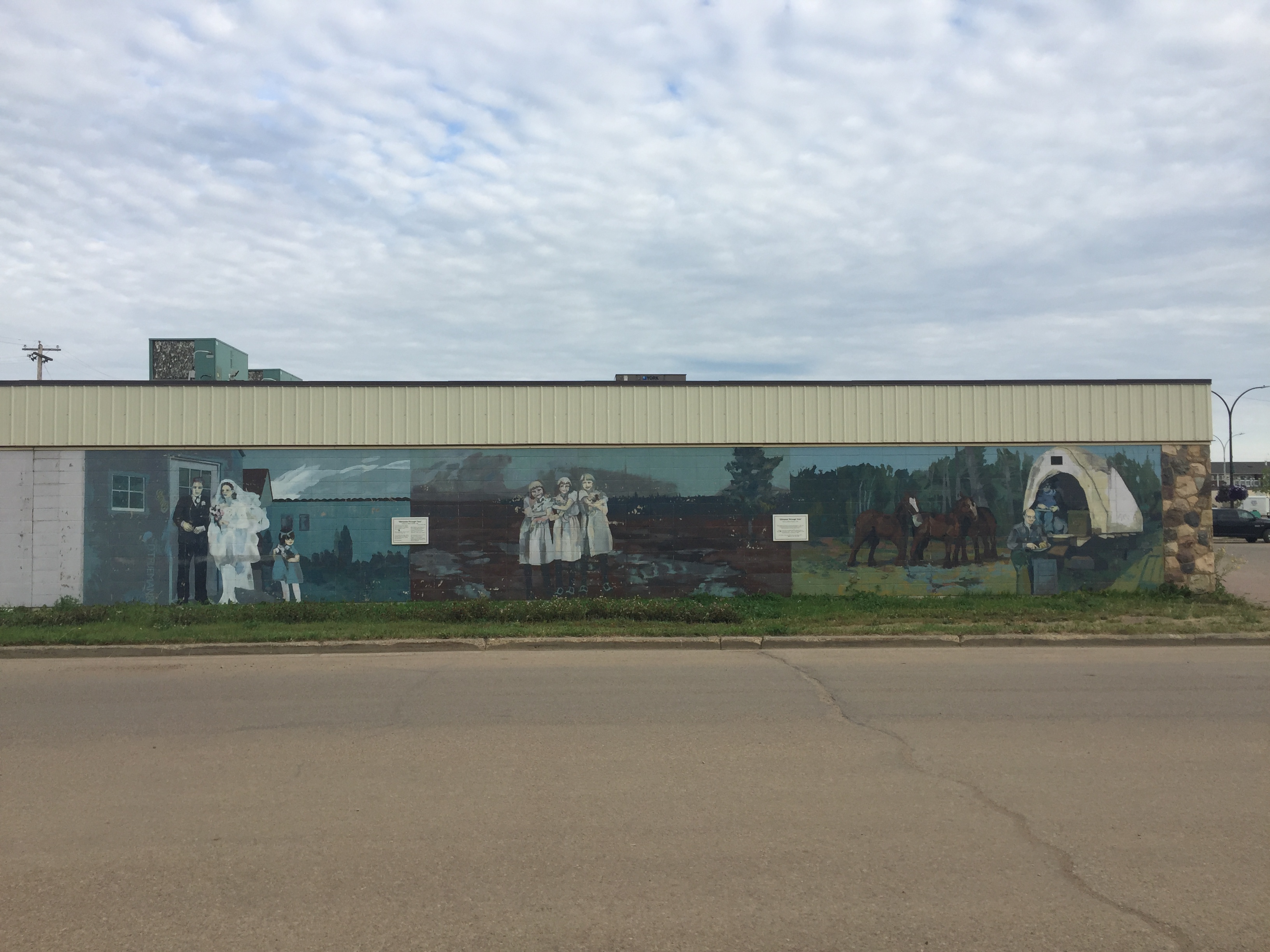
After Manning, the next notable location was High Level where I stopped after a 600+ km drive for another overnight hotel stay. High Level is in northern Alberta located at the intersection of the Mackenzie Highway and Highway 58, about equidistance between Edmonton and Yellowknife. It has a population of about 4,000 and provides services for susbtantially larger area having about 20,000 people. After closure in 2007, local oriented strnd board (OSB) mill in High Level reopened in 2015. Other forestry operations include a dimension lumber mill located in the town's industrial park. High Level has the most northerly grain elevator in Canada and is the terminus for a large agricultural area of approximately 142,000 cultivated hectares of farm land in the region with farmers trucking their grain from as far away as 120 km.
Most of the town's businesses and services are spread along the highway with residential areas located further back from the highway. After having been in the car for much of the day and getting settled in the hotel, I explored on the streets near the hotel and found one of the interesting features being a few murals reflecting local history.
The hotel was comfortable, quiet and not busy. For dinner I found a local takeout and brought food back to the hotel; for breakfast the hotel had a few items for take away including good coffee. I also refueled the car so I would have a full tank for the morning.
August 9:
It was another reasonably early start and I was driving by 8:00 am. Today's destination was Yellowknife and being reunited with my grandson and his parents. The highway from High Level to the NWT border is straight with no place to refuel or eat unless driving into a town or village, typically several km away. So, my first stop was the NWT border at the 60th parallel latitude where all traffic was required to stop for a COVID health check that meant answering some questions, providing photo identification and providing the paperwork showing the approval for me to enter the territory. It was straightforward and only took a few minutes.


After leaving the border check stop, my next destination was the hamlet of Enterprise (population of 120) about an hour north of the border. The scenery in this area was much more appealing than along the highay through northern Alberta. Enterprise was founded in 1948 to serve travellers on the first highway constructed in the Northwest Territories. At the juntion in Enterprise, one can take Highway 2 northeast to Great Slave Lake and the communities of Hay River, Fort Resolution and Fort Smith. I took the Mackenzie Highway northwest and, after a little more than an hour, came to the junction with the Yellowknife Highway and the bridge across the Mackenzie River.
In Enterprise I stopped to refuel my car and refuel myself with get a large coffee for the next stage of the drive. This is an important place to stop because there are few places to purchase gas in this part of the NWT.
Driving on the 1.6 km long bridge over the river was a highlight for me. Prior to the bridge's opening in 2012, crossing the river was either by ferry or ice road in the winter. Construction of the bridge made it notably more efficient to travel to Yellowknife by highway year round. The Mackenzie River is Canada's longest river at 1,738 km.
The next highlight was driving throug the 10,000 square kilomtre Mackenzie Bison Sanctuary and seeing many bison along the highway. There are many warning signs for drivers to be alert for bison on or near the highway that may require stopping or driving more slowly.
In the last part of the journey I encountered some highway resurfacing that slowed driving, but still arrived in Yellowknife in time for dinner! It was a wonderful reunion and the start of a month long visit. With quite a few COVID related restrictions still in place, there were limits to what we could do and some businesses and attractions were closed. Having my own vehicle there made it easier to get around the city a bit and see some familiar sites. The weather was nice - sunny and warm - so my grandson and I spent plenty of time outside. I was happy to prepare a number of dinner meals and take on a couple of small projects around the house. I also got to play with lots of LEGO and other interesting things.
Weaver & Devore - a Yellowknife landmark
Mural - Yellowknife Old Town
Park bench in honour of missing and murdered Indigenous women
When folks were at work or school on my last Friday (Sept. 3) in Yellowknife, I went for a great hike at a place I had wanted to visit for many years - Cameron Falls. It is located in Hidden Lake Territorial Park approximately an hour drive from Yellowknife. Leaving from a small parking lot, it is about a 20 minute hike to a point that overlooks the falls and provides spectacular views. After spending some time soaking in the scenery, I walked along the Cameron River above the falls a short distance to cross a foot bridge and then walk along the opposite side for a short distance. The trail is well signed and, while there are ups and downs, the walking conditions are very good and not physically demanding. Here are a few photos.
Sept. 8:
After hugs and goodbyes, I left Yellowknife shortly after 8:00 am to start the journey back to Victoria. It was a great day weather wise for driving - not many vehicles on the highway and only a short section (about 8 km) had any kind of road work underway. Along the highway north of Fort Providence, I again saw bison in a few places and also made a couple of short stops to enjoy the scenery.
Small lake about an hour outside Yellowknife
I stopped again in Enterprise to refuel and interestingly the woman at the cash remembered me from a month earlier. A short distance after Enterprise I stopped to take in the views of the impressive Alexandra Falls on the Hay River. Here are a few photos.
After crossing the border into Alberta, much of the route to High Level goes through boreal forest and the Canadian Shield - a bit boring but beauty pops out occasionally.
Sept. 9-10:
Day two of the return trip was all about driving and finished in Hinton, Alberta where I stayed in a hotel that was completely full (good thing I had made a reservation). I had driven through this area a few days and, while it doesn't have much appeal to me, there are plenty of services for travellers as well as local.
Day three of my drive provided a sharp contrast with the previous two days as soon as I entered Jasper National Park and was surrounded by mountains! When arriving at the town of Jasper, I turned south and took the Icefields Parkway through spectacular mountains and glacier fields. Below are a few photos of this section.
My next stop was in Golden, BC to check the recently opened Golden Skybridge with its two impressive cable suspenion bridges for people to cross. The bridges corss over an expansive canyon with one bridge being 130 metres above the canyon and 150 metres in length; the other bridge ia 80 metres above the canyon and 140 metres long. The set up involves crossing the longer bridge and then returning on the other bridge. Getting to the first bridge and between bridges involves a short walk on a beautiful forest trail.
Taking in the suspension bridge experience involves first crossing the longer bridge and returning on the other bridge. The views are spectacular and actually walking on the bridges is a bit of a rush as the bridges sway when people are walking on them and the sway can be more noticeable as the number of people on the bridge increases. There were only a few people on the bridges when I was there, but all their movements could be felt even if they were not close to me. If there is a strong wind, the bridges are closed as a safety precauton. See photos below.
After the Skybridge adventure, I drove 150 km further before stopping near Revelstoke, BC, where I treated myself to a very comfortable stay at the local Coast Hotel.
Sept. 11:
The 4th and last day of my return trip started with a stop in downtown breakfast for a healthy breakfast and excellent coffee at Dose!! What a great name for a coffee shop!
While most of day 4 was focused on driving, a highlight was stopping in Kamloops for a short visit with a friend/former work colleague. We had not seen each other for several years, but had stayed in contact. It was a great stop!
From Kamloops, the next destination was Tsaawassee to catch a ferry back to Vancouver Island and home. The highway traffic was not heavy and I managed to catch an earlier ferry than anticipated.
It was a wonderful trip with the best part being the long visit with my Yellowknife family. The driving was fun and interesting as were various stops and little adventures along the way. Without hesitation, I would make this drive again! I understand there is a route to Yellowknife through the southern Yukon - that sounds appealing!